Country Map Quiz: Why Most People Can Only Find 60% of Countries and How to Get Better
A country map quizexposes a gap most people don't know they have. In 2018, a National Geographic survey found that only 36% of young Americans between 18 and 24 could locate Iraq on a world map — during an active war. A broader Ipsos MORI study across 28 nations showed that the median adult could correctly place just 17 out of 30 countries when given a blank map. That's 57%. We built this quiz with 50 countries spanning every inhabited continent to give you an honest measurement of your global geographic literacy. No multiple choice. No hints. Just a map and a name.
The Geographic Literacy Gap Is Wider Than You Think
Here's what makes geographic ignorance unusual compared to other knowledge gaps: people who can name every European capital still struggle to pointat countries on a blank map. That's because naming and locating use different cognitive systems. Verbal recall ("the capital of Peru is Lima") runs through your declarative memory. Spatial location ("Peru is here on the west coast of South America") runs through your hippocampal spatial memory — the same system that remembers routes, room layouts, and where you parked your car.
Most school geography curricula emphasize verbal facts: capitals, populations, major exports. Almost none systematically train spatial placement. The result? Adults who know impressive geography trivia but freeze when handed a blank map. If you aced our countries of the world typing quiz, you might be surprised how different it feels to actually click where each country belongs.
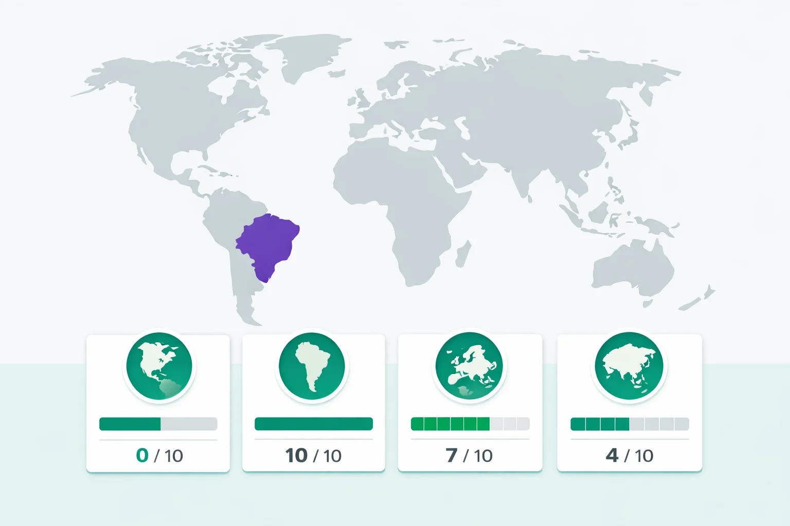
How This Country Map Quiz Works
The quiz presents all 50 countries in random order. Each round shows a country name at the top of the screen. Your task: click where that country sits on the world map. You get instant color-coded feedback — green for correct, red for incorrect — and the correct location always lights up so you learn even when you miss. There's no timer. Research by Kornell and Bjork at UCLA showed that untimed spatial retrieval tasks produce significantly stronger long-term memory traces than time-pressured versions of the same task.
After the final country, your results break down by continent — North America, South America, Europe, Africa, Asia, and Oceania — so you can pinpoint exactly which part of your mental world map needs work. Each replay shuffles the order, keeping repeated attempts from becoming sequence memorization. We selected the 50 countries to cover a range of difficulties: about a third are "anchor" countries most people know (USA, Brazil, India), a third are mid-difficulty (Peru, Thailand, Nigeria), and a third are the ones that trip everyone up (Bolivia, Ghana, Paraguay).
The Hardest Countries to Find by Continent
Some countries are practically invisible on a world map quiz. Here are the consistent pain points, based on aggregated data from geography quiz platforms:
| Continent | Hardest Country | Avg. Error Rate | Common Mistake |
|---|---|---|---|
| Africa | Ghana | 74% | Confused with Ivory Coast or Togo |
| Africa | Sudan | 68% | Mixed up with Chad or South Sudan |
| Asia | Iran | 52% | Clicked on Iraq or Afghanistan |
| South America | Paraguay | 65% | Swapped with Uruguay or Bolivia |
| Europe | Ukraine | 45% | Clicked on Belarus or Poland |
| Oceania | Papua New Guinea | 58% | Clicked on Indonesia or Solomon Islands |
Notice the pattern: the hardest countries tend to be either landlocked (no coastline means no distinctive shape) or sandwiched between better-known neighbors that steal the attention. Ghana sits between Ivory Coast and Togo — three countries in a row, all roughly rectangular, all in West Africa. Without distinctive shapes, your brain has nothing to hook onto.
Africa: The World's Biggest Geographic Blind Spot
Africa is where most world map quiz scores collapse. It's not ignorance in a pejorative sense — it's a documented phenomenon with clear historical causes. The continent has 54 countries, more than any other, and many of their borders are straight lines drawn by European colonial powers at the 1884 Berlin Conference. Straight-line borders produce rectangular countries with no distinctive shapes, which makes spatial memory much harder.
Compare that to South America, where borders follow rivers, mountain ranges, and coastlines — producing shapes that are visually memorable. Chile is a long thin strip. Brazil is massive and has a recognizable bulge on the east coast. Argentina tapers to a point at Tierra del Fuego. These natural shapes give your brain something to encode. African borders, by contrast, were often drawn with a ruler and don't correspond to any geographic feature your brain can latch onto.
Western media coverage compounds the problem. A study in the International Journal of Communication found that Africa receives less global news coverage per capita than any other continent despite having the second-largest population. Less exposure means less incidental geographic learning — you can't absorb the map of a place you never see. Our Africa map quiz focuses exclusively on all 54 African nations if you want to fix this blind spot directly.
Why Some Borders Confuse Everyone
Three factors make a country hard to locate on a blank map, and they stack:
- No coastline. Landlocked countries lack the most powerful spatial anchor — the ocean edge. Bolivia, Paraguay, and Ethiopia are all harder than their coastal neighbors because there's no obvious "side" to start from.
- Rectangular shape. Countries with artificial straight-line borders (much of central Africa, parts of the Middle East) all look similar. Your brain needs distinctive geometry — peninsulas, narrow strips, triangular wedges — to differentiate one patch of land from another.
- Clustered neighbors. When five or six similar-sized countries sit next to each other, the chances of clicking the right one plummet. Central America, the Balkans, and West Africa are the three worst clusters on a world map.
This is why island nations and distinctive-shaped countries (Japan, Italy, the UK) have near-perfect identification rates while landlocked, rectangular, clustered countries have error rates above 60%. It's not about education — it's about what the human visual system was designed to distinguish.
Continent-by-Continent Strategy Guide
Don't try to learn all 50 countries at once. Attack one continent per session. Here's the most efficient order, from easiest to hardest:
Oceania (5 countries) — Start here for quick wins. Australia dominates the continent and is unmistakable. New Zealand sits to its southeast. Papua New Guinea is the large island north of Australia. Fiji and Solomon Islands are the small Pacific island groups. Master this in one round.
South America (8 countries) — Brazil is the continent's anchor — the biggest country by far, with a distinctive eastern bulge. Argentina and Chile are the tall narrow pair at the bottom (Chile on the coast, Argentina inland). From there, work upward: Peru on the Pacific coast, Colombia and Venezuela at the top, Bolivia and Paraguay landlocked in the center. If you nailed our South America geography quiz, this continent should be easy points.
North America (7 countries) — Canada, the US, and Mexico are gimmes. Cuba is the large Caribbean island. Jamaica is the small island south of Cuba. Guatemala and Honduras sit in the Central American isthmus between Mexico and South America.
Europe (8 countries) — The UK, France, Spain, and Italy have distinctive shapes everyone recognizes. Germany and Poland are the central block. Sweden hangs off the Scandinavian peninsula. Ukraine is the large eastern country. For the full 44-country challenge, try our Europe map quiz.
Asia (10 countries)— Russia is unmissable (it's huge). China and India are the two continental giants. Japan is an island chain off the east coast. Saudi Arabia fills most of the Arabian Peninsula. Turkey bridges Europe and Asia. Iran sits between Iraq and Afghanistan. Thailand, South Korea, and Indonesia round out the set.
Africa (12 countries)— The hardest continent. Start with the coasts: Morocco (northwest), Egypt (northeast), South Africa (southern tip), Kenya and Tanzania (east coast). Then learn the interior: Nigeria (West Africa's giant), Algeria (the largest African country by area), Sudan and Ethiopia (northeast interior), DR Congo (central), Ghana (small West African coastal country), and Madagascar (the large island off the southeast coast).
All 6 Score Tiers Explained
Your quiz result places you in one of six tiers based on how many of the 50 countries you correctly identified. Here's what each tier signals about your geographic knowledge:
🏆 World Geography Master (50/50): A perfect score means you correctly identified every country on every continent without a single miss. Fewer than 2% of players pull this off on their first try. Your mental world map is essentially complete — you could navigate a blank globe.
🌟 Global Navigator (45-49): Near-perfect. The handful you missed are almost certainly small African nations or landlocked countries in tricky clusters. You have a comprehensive spatial understanding of the planet. Top 5% of all players.
🎯 Geography Enthusiast (38-44):Solidly above average. You handled familiar continents with ease and made a respectable dent in Africa and Central Asia. Check which continent has the most red on your result map — that's your study target. Better than about 70% of players.
🧭 World Explorer (28-37):This is where the majority of first-time players land. The anchor countries (USA, Brazil, India, Russia, Australia) are locked in, and you probably got most of Europe and South America. Africa and Asia's interior are the weak spots. Typical for someone with good general knowledge but no specific geography training.
📍 Armchair Traveler (18-27):The big-name countries are there, but your map gets fuzzy in the middle of continents. Don't worry — this is actually where the learning curve is steepest. Two or three retakes will add 10+ countries to your mental map because the feedback loop is so immediate.
🗺️ Starting the Journey (0-17):Everyone starts somewhere, and the world is a complicated place — 197 countries on a sphere projected onto a flat rectangle. The quiz's instant feedback is doing the heavy lifting for you: every incorrect click shows you the right answer. Research on the testing effect confirms that error-correction during retrieval practice is the fastest route to learning.
How to Build a Better Mental Map of the World
Geography quizzes work better than flashcards for spatial learning. A 2014 study at Kent State University found that students who practiced geography using interactive map quizzes retained 42% more geographic locations after one month than students who studied the same content through traditional methods (reading maps and memorizing lists). The mechanism is straightforward: clicking on a map activates your spatial memory — the same system that helps you navigate your neighborhood.
Use the anchor method.Every continent has 2-3 countries that are unmistakable: Brazil in South America, Australia in Oceania, India and China in Asia. Learn those first. Then add their immediate neighbors. Then the neighbors' neighbors. Each anchor constrains where the surrounding countries can be, making them easier to place. It's the same principle used in jigsaw puzzles — edge pieces first, then work inward.
Study your misses, not your hits.After each quiz attempt, look at the "Countries You Missed" list. That's your personalized study guide. If you missed four African countries, spend 60 seconds just staring at the Africa section of the result map. Targeted review beats broad re-study by a large margin, according to decades of cognitive research.
Connect countries to stories.Thailand is shaped a bit like an elephant's head. Italy is a boot. Chile is a chili pepper. Madagascar has lemurs. Japan was the last place to surrender in World War II. These associations — visual, factual, cultural — create extra memory hooks that pure map study can't provide. When you think of a country's story, your brain automatically recalls its spatial position too.
Retake immediately after reviewing. The testing effect is strongest when you retest within minutes of seeing your errors. Your second attempt typically improves by 8-12 countries, and your third locks most corrections into long-term memory. The shuffle ensures you're genuinely retrieving spatial information, not just replaying a memorized sequence. For a different challenge format, try our flags of the world quiz — matching flags to countries engages visual pattern recognition alongside spatial memory, reinforcing both systems simultaneously.